
West Allis Neighbor Record Sources
No single roll identifies every household around a West Allis address. The public record instead offers layers. The parcel map is best for the physical block and owner names. The assessor adds a current property snapshot. MyVote answers a matched voter's registration question or an address's polling context, while neighborhood groups provide public contacts rather than member lists.
| Source | What It Shows About a Block | Access |
|---|---|---|
| West Allis GIS parcel layer | Parcel shapes, tax keys, situs, owners, mailing fields, neighborhood, zoning | Public gallery and ArcGIS layer |
| Assessor property record | Current owner, property address, class, value, record card | City property search or office request |
| MyVote Wisconsin | Matched registration details or polling and ballot context | Name and birth date, or exact address |
| Neighborhood associations | Public group contacts, events, and civic connection | City handbook, email, social links |
| Directories and census | Older occupants and historic household context | Library collections and public schedules |
| Permits and code files | Dated work, inspections, and disclosed case details | City portal or records request |
Each source proves something different. A parcel owner may live elsewhere. A renter may never appear on a property card. Public association contacts show how to reach the group, not which nearby homes belong to it.
Map a West Allis Block
The West Allis GIS Public Gallery is the map entry point. Its parcel layer exposes tax key, property address, owner and secondary owner, mailing label, legal description, neighborhood, zoning, land use, living units, square footage, last sale date, and assessments. Those fields let a reader move outward from one parcel without assuming that consecutive street numbers share a boundary.
- Locate the target address and confirm it falls inside the West Allis boundary.
- Click the parcel polygon and copy its tax key, situs address, owner, mailing fields, and legal description.
- Click each polygon that shares a boundary, then inspect parcels across the street and at the corner.
- Record each parcel separately, especially when one owner holds several lots or a corner parcel faces another street.
- Use zoning, neighborhood, and census layers for geographic context, not as evidence of who lives there.
The REST service supports distance queries, but no consumer-facing radius button was verified in the gallery. A cul-de-sac, alley, corner, or multi-lot site is best read by parcel geometry. For a complete named-road chain, switch to the West Allis street directory workflow.
Read West Allis Parcel Clues
The city parcel-layer inventory is captured below. It is a data layer, not a deed or legal survey.
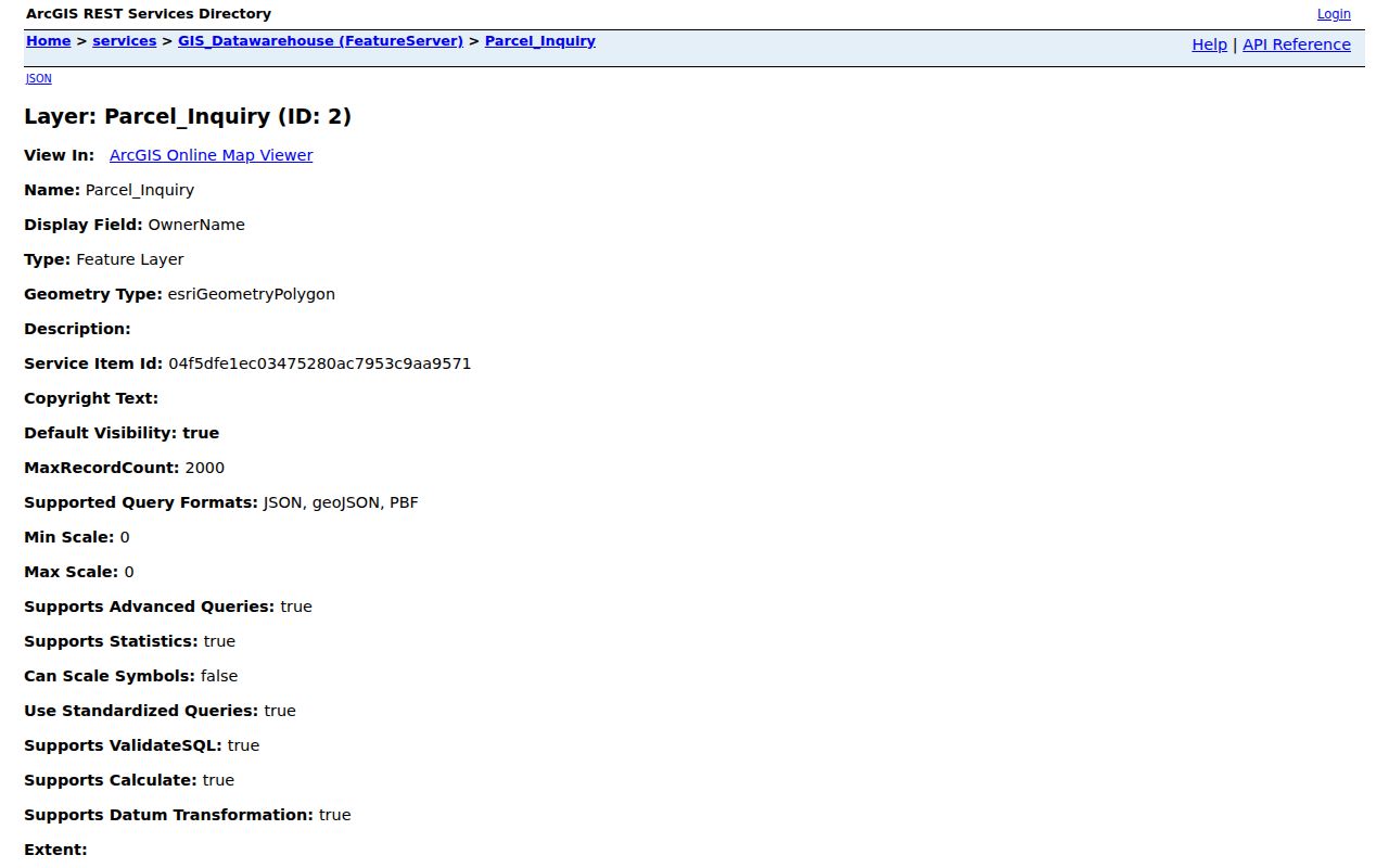
The image reinforces the most important distinction: PROPERTY_ADDRESS and FULL_ADDRESS are situs fields, while OwnerAddress, OwnerCityState, OwnerZip, and OwnersMailingLabel are mailing fields. A mailing address can help locate an owner, but it does not establish which neighbors reside at either address.
- Parcel
- A mapped unit of land tied to a tax key and legal description.
- Situs address
- The address where the parcel or building is located.
- Mailing address
- The destination used for owner correspondence, which may differ from the property.
- Legal description
- The recorded land description that survives changes in street labels.
County land-information data can supplement the city layer. County maps remain reference products and do not replace a recorded survey. Property and address datasets refresh in alternating months, so save the date of each search.
Confirm West Allis Neighbor Owners
The West Allis Assessor maintains ownership information and values taxable property. Its property search and record-card links are the practical check on a parcel popup. Compare the tax key, legal description, and owner name across both systems. A last sale date is a lead, not proof about your neighbors.
When ownership must be verified, search the Milwaukee County Register of Deeds. A deed names the parties and describes the land. It still does not list every occupant. If a business, trust, or estate holds title, avoid turning the entity name into a guess about the household.
Keep the records separate. Property address, owner mailing address, and actual occupancy are three different facts.
What MyVote Says Nearby
MyVote Wisconsin is not a browseable street roster. A registration search requires first name, last name, and birth date. An address search requires street address, unit, city, and ZIP, and is designed for polling-place and ballot information. A matched voter may see current registration information, election officials, voting activity, and a ten-year activity history, but not ballot choices.
A full Wisconsin voter file can be ordered through Badger Voters and filtered by geography such as municipality, ward, or precinct. Requester terms, Wis. Stat. §§ 6.36 and 6.47, protected electors, and sensitive-field restrictions still apply. A GIS block, census block, and election ward are not interchangeable.
Note: MyVote can confirm a properly matched elector; it cannot reveal every person who lives around an address.
West Allis Neighborhood Contacts
West Allis GIS names 26 neighborhoods, while the city recognizes eight neighborhood associations in its current handbook. These groups help neighbors connect through public contact routes and civic activity. None publishes a public member-household directory in the research record.
| Association | Public connection | Published roster |
|---|---|---|
| City Center | Email and social contact | No member list found |
| Conrad Gardens | Email and social contact | No member list found |
| East Allis | Public contact and social link | No member list found |
| Fairview Park | Public email | No member list found |
| Liberty Heights Park | Email, social, and website | No member list found |
| Orchard Hills | Email and social contact | No member list found |
| Rainbow Gardens | Email and social contact | No member list found |
| Wood Dale | Public social contact | No member list found |
The city community-engagement office also supports the Neighborhood Leadership Alliance, an informal monthly group for recognized association leaders and groups forming. Public contacts are the right route for events, boundaries, and current recognition status.
Resolve the Rosehill Map Quirk
The official neighborhood map dated May 7, 2024 labels Rosehill, while the current handbook lists the eight groups above and omits Rosehill. This is a date-and-version difference, not proof that a group vanished. Ask Planning and Zoning which recognition list controls before telling neighbors that a current association represents their block.
The distinction matters because a named GIS neighborhood is not the same as a recognized association. Association boundaries may also differ from historic neighborhood names, election wards, postal areas, and census geography. Use the map to identify a place, then use the city's current contact material to identify the organization.
Connect With West Allis Neighbors
Public civic groups add context without exposing private households. The Neighborhood Leadership Alliance is the city-backed connection among associations. Chamber, Rotary, congregations, and other organizations may publish officers, event contacts, or business members, but those lists describe public roles rather than residence.
Permits and code records add block history. West Allis lists building, demolition, electrical, HVAC, plumbing, erosion-control, and plan-review routes. Code Enforcement handles complaints, inspections, zoning, and property-owner registration. If an online record is absent, request the file by exact address or tax key through the West Allis open-records channel. Ask for dates and disclosed documents, not private household data.
A permit can date work on a structure. It cannot prove that the applicant lived there. A complaint can open a city case, but it does not prove the complaint was sustained.
Choose Official West Allis Sources
Commercial neighbor-search products often blend stale files and inferred household links. Official sources are narrower, but they identify the custodian, field definitions, and correction route. Use each record only for the fact it was made to document.
| Question | Official source | Commercial category |
|---|---|---|
| Who owns the parcel? | Assessor, GIS, then deed | May repeat an old owner |
| What parcels touch it? | City GIS polygons | May rely on address proximity |
| Is a voter record matched? | MyVote under its field rules | May infer a person-address link |
| How can I meet the group? | City association contacts | Cannot establish civic membership |
Correct city property data with the assessor, recorded ownership with the Register of Deeds, voter registration with the clerk or Elections Commission, and association details with the city community-engagement staff or group contact.
Read Historic West Allis Blocks
A 1948 UWM West Allis map shows wards, precincts, schools, and polling places and carries March 1950 boundary annotations. It can explain old election geography, but it cannot describe current registration. Regional reverse directories from 1921 forward and public census schedules through 1950 can identify past households around the block.
West Allis also expanded through 1950s annexations from Greenfield and Wauwatosa. A historic address may sit under a different municipal or township label. Postal labels add another wrinkle: Milwaukee, West Milwaukee, Greenfield, and West Allis can appear as accepted localities for area ZIPs. Neither mailing city nor ZIP should be treated as the legal city boundary.
Protect West Allis Neighbor Privacy
Public parcel data cannot show every renter, child, guest, or mailing recipient. MyVote does not provide a block roster through its address mode. Utility customer accounts and DMV personal addresses are not public neighbor directories. Wisconsin Safe at Home protects a participant's actual address through an assigned address, and confidential elector rules shield protected voter information.
Use nearby records for civic curiosity, reconnecting, scam checks, property questions, and personal safety awareness. Do not infer private relationships from a shared mailing address or watch someone's routine. Verify any material fact with the custodian and allow for data-update lag.
Lawful use. Never use a West Allis neighbor lookup to track, intimidate, harass, or harm a person. Respect protected addresses and private household details.